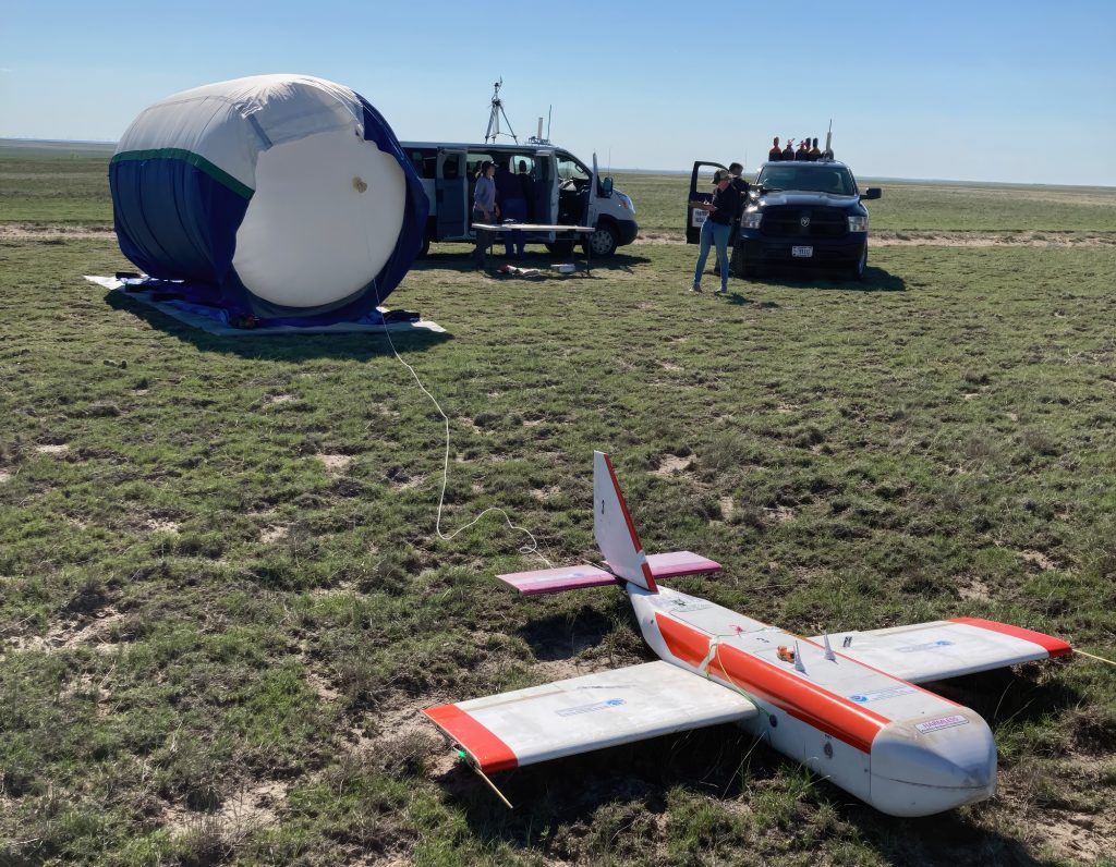
HORUS uncrewed glider system completes sampling mission to 90,000 feet
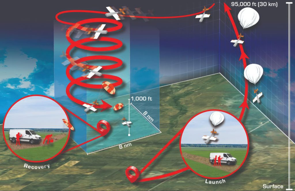
The quest by Global Monitoring Laboratory scientists to develop a reliable, cost-effective way to study Earth’s stratosphere passed a significant milestone on May 17 when a remotely controlled glider, carried to an elevation of 90,000 feet by a weather balloon, returned to its launch location on Colorado’s Pawnee National Grasslands with its scientific payload intact.
The successful mission marked the next step in a four-year effort to deploy and recover an atmospheric sampling and measurement system from that altitude in controlled airspace.
“To collect any highly accurate measurements from a balloon-borne platform in controlled airspace and have it return to where you launched is a first for the non-military research community,” said Colm Sweeney, the lab’s Associate Director of Science.
Balloons have long been essential tools for weather and climate research, but advancements in the measurement technologies they use have always been limited by the challenge of tracking and recovering their data and payloads. While balloons can easily surpass typical aircraft altitudes of 45,000 feet on the way up, they drift with the wind, resulting in instruments landing up to 100 miles from the launch point, or being lost. The lack of control often dictates the type and quality of instruments included in the payload.
GML scientists, with support from NOAA’s Office of Research Transition and Application and Office of Marine and Aviation Operations have solved this problem by combining the tried-and-true weather balloon with modern uncrewed aerial vehicle (UAV) technology. The balloon lifts a remote-controlled glider with an instrument package installed in its belly to altitudes up to 90,000 feet. The glider is programmed to release from the balloon at a specific altitude and then navigate back to a loiter point above the landing spot, where it circles until the launch crew takes over controls and lands it.
The project, called the High-altitude Operational Return Uncrewed System, represents a unique collaboration between NOAA and the Federal Aviation Administration (FAA), which are both seeking ways to allow UAVs to fly beyond the operator’s sight. While UAVs offer increased opportunities for weather and climate research, the need to restrict flight paths to allow remote control has created a huge barrier to UAV research and operational use.
Developed by scientists from NOAA, CIRES, the University of Colorado, Arizona State University, Delta Zee Solutions, and Spektreworks, the system, dubbed HORUS after the falcon-headed Egyptian god of the sky, provides a predictable and trackable trajectory back to its launch location, making it easy for FAA air traffic control to ensure the safety of other aircraft.
With few trees, water hazards or topography, eastern Colorado grasslands offer an ideal opportunity to demonstrate the system’s reliability. On the recent test flight, the glider for the first time successfully returned a payload consisting of two Global Monitoring Lab-designed AirCore autonomous atmospheric sampling instruments. The AirCore is a lightweight, whole-air sampler that provides a means for retrieving calibrated, vertical profiles of trace gases. Constructed around a long, coiled tube, the AirCore provides one of the only routine, accurate, low-cost pathways for sampling over 90% of the atmospheric column relative to other atmospheric sampling platforms available.
The lab’s ultimate goal is to deploy the HORUS systems to locations where balloon retrieval would be nearly impossible or a payload would be lost or might come down in a populated area, said NOAA’s Bianca Baier, a Global Monitoring Laboratory researcher.
“That means we may be able to conduct high-altitude sampling from an island, or a ship, or other places where a payload would be lost or create a potential hazard on descent,” Baier said.
It also means scientists can improve the quality of balloon-borne atmospheric measurements. “If you can safely and reliably land a payload, you might buy more expensive instruments that provide better performance,” she said.
For more information, contact Theo Stein, NOAA Communications: theo.stein@noaa.gov.