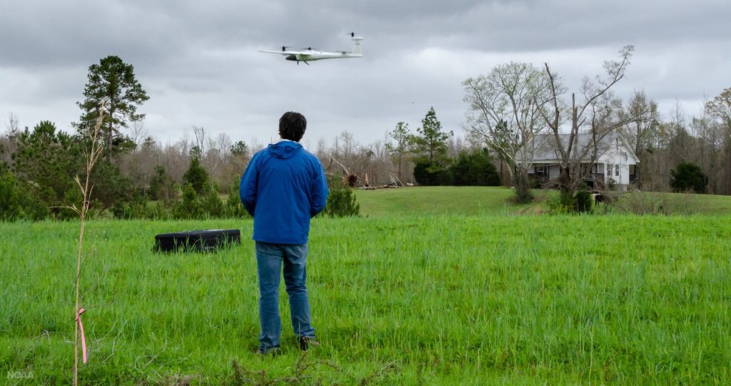
NOAA scientists use drones to see tornado damage in remote areas
Scientists hope images from the research drones will improve our understanding of tornadoes and lead to better forecasts.
Kimberly Hoogewind is a research scientist at the Cooperative Institute for Mesoscale Meteorological Studies (CIMMS) at the University of Oklahoma, working in affiliation with the …
Turning a fascination with thunderstorms into a career in severe weather and climate Read More >
All tornadoes — whether large or small — originate from thunderstorms, but not all thunderstorms are the same. Nighttime twisters, summer tornadoes and smaller events can be tougher to forecast. New research in the Bulletin of the American Meteorological Society presents a method for rating the skill of tornado warnings based on environmental challenges.
This study used 20 years of Oklahoma Mesonet data to investigate the changes of near surface water vapor mixing ratio (qv) during the afternoon to evening transition (AET). Similar to past studies, increases in qv are found to occur near sunset. Next to known changes in low-level wind shear, these changes in instability and moisture demonstrate new ways the AET can modify the presence of the key ingredients relevant to explaining the climatological increase in severe convective storm hazards around sunset.
Evaluation of numerical weather prediction (NWP) is critical for both forecasters and researchers. Through such evaluation, forecasters can understand the strengths and weaknesses of NWP guidance, and researchers can work to improve NWP models. However, evaluating high-resolution convection-allowing models (CAMs) requires unique verification metrics tailored to high-resolution output, particularly when considering extreme events. Metrics used and fields evaluated often differ between verification studies, hindering the effort to broadly compare CAMs. The purpose of this article is to summarize the development and initial testing of a CAM-based scorecard, which is intended for broad use across research and operational communities and is similar to scorecards currently available within the enhanced Model Evaluation Tools package (METplus) for evaluating coarser models.
AMS Weather and Forecasting journal
Due to lack of high spatial and temporal resolution boundary layer (BL) observations, the rapid changes in near storm environment are not well represented in current convective-scale numerical models. Better representation of the near storm environment in model initial conditions will likely further improve the forecasts of severe convective weather. This study investigates the impact of assimilating high temporal resolution BL retrievals from two ground-based remote sensing instruments for short-term forecasts of a tornadic supercell event on 13 July 2015 during the Plains Elevated Convection at Night field campaign. Results indicate a positive impact of Atmospheric Emitted Radiance Interferometer (AERI) and Doppler Lidar observations in forecasting Convective Initiation (CI) and early evolution of the supercell storm. The experiment that employed the AI technique to assimilate BL observations in DA enhances the humidity in near storm environment and low-level convergence, which in turn helps forecasting CI. The forecast improvement is most pronounced during the first ~3-h. Results also indicate that the AERI observations have a larger impact compared to DL in predicting CI.
Observations of near-surface vertical wind profiles and vertical momentum fluxes obtained from a Doppler lidar and instrumented towers deployed during VORTEX-SE in the spring of 2017 are analyzed. In particular, departures from the predictions of Monin–Obukhov similarity theory (MOST) are documented on thunderstorm days, both in the warm air masses ahead of storms and within the cool outflow of storms, where MOST assumptions (e.g., horizontal homogeneity and a steady state) are least credible. In these regions, it is found that the non-dimensional vertical wind shear near the surface commonly exceeds predictions by MOST. The departures from MOST have implications for the specification of the lower boundary condition in numerical simulations of convective storms. Documenting departures from MOST is a necessary first-step toward improving the lower boundary condition and parameterization of near-surface turbulence (“wall models”) in storm simulations.