On September 30, 2021, a saildrone uncrewed surface vehicle made history by intercepting the eyewall of Hurricane Sam in the northwestern tropical Atlantic, recording a viral video of what it’s like to be tossed around by 100 mile-per-hour winds and 30-foot high waves.
The Guinness Book of World Records later certified that a 126.4 mile-per-hour wind gust recorded by the bright orange 23-foot saildrone in the core of the Category 4 storm was a new world record for an uncrewed surface vehicle.
But the most long-lasting impact of Saildrone Explorer SD 1045’s trailblazing research voyage may come from the continuous readings collected by the craft’s temperature sensors. Timely, accurate upper-ocean observations like those collected during the mission could directly benefit hurricane intensity forecasts – if they can be swiftly provided to weather forecast systems, according to new research by NOAA oceanographers published in Frontiers of Marine Science.
Credit: Ali Hochberg/Bermuda Institute of Ocean Sciences
“Sam turned out to be one of the longest and strongest hurricanes in our historical record,” said Andrew Chiodi, an oceanographer with NOAA’s Pacific Marine Environmental Laboratory (PMEL). “We were targeting the northeast eyewall and the intercept was a bulls-eye. Until now, we haven’t had a surface platform that we can steer into a hurricane while it continuously measures air-sea interactions, and transmits data in near real-time for use by numerical hurricane forecast models.”
Early and accurate forecasts of storm tracks and intensity are vital for protecting life and property from hurricane impacts. During the past decade, however, the accuracy of hurricane track predictions has substantially outpaced those for storm intensity, which is influenced by transfers of heat and momentum across the ocean surface during tropical cyclone development. Sea surface temperature has long been used as a statistical predictor of intensity.
Analysis by Chiodi and his research team found that the observations and measurements collected by the ocean robot revealed surface ocean temperatures had unexpectedly risen during the first half of the storm. These changes were not captured by satellites, profiling floats, or hurricane-hunting aircraft that provide the data used by hurricane forecast models, said co-author Greg Foltz, a NOAA oceanographer with the Atlantic Oceanic and Meteorological Laboratory.
As a result, the forecast model predicted surface waters to be cooler than they actually were. This caused the model to underestimate the flow of heat from the ocean into the storm near the eyewall, which reduced the forecasted potential intensity of the storm.
Hardy, adaptable, and cost-effective
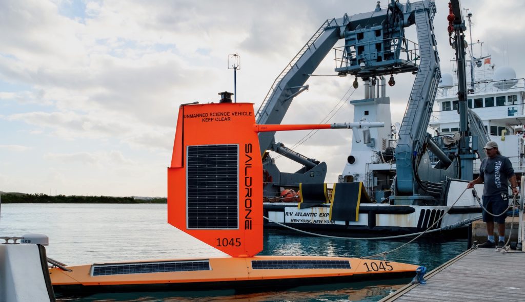
Enter the saildrone. Remotely piloted and powered by wind and solar energy, these rugged ocean robots can make multiple simultaneous environmental observations including wind speed, wave height, temperature, pressure and salinity in places too dangerous for people to venture. Saildrones are equipped with Global Positioning System and an onboard computer, enabling the vehicles to navigate to prescribed waypoints, autonomously adjusting for wind direction and current. Each vehicle is supervised 24/7 by operators at Saildrone Mission Control in Alameda, California.
Credit: Saildrone Inc.
PMEL began a partnership with Saildrone, Inc. in 2014 to adapt the uncrewed surface vehicles to collect high-quality oceanic and atmospheric observations.
In addition to the vehicles themselves, Saildrone, Inc. provides engineering expertise in vehicle design, software, electronics and operations. PMEL provides engineering expertise on sensors, sensor sampling schemes, telemetry protocols and access to calibration equipment and facilities.
NOAA-Saildrone missions have included surveys of the U.S. west coastal waters around Alaska, basin-scale crossings from Hawaii to San Diego and San Francisco to the Equatorial Pacific, and high-latitude missions in the Bering and Chukchi Seas, with tasks ranging from tracking fish and mammals, measuring dissolved carbon dioxide, salinity, and ocean acidification, detecting and tracking oil seeps and spills, charting underwater bathymetry for safe navigation, and surveying the Arctic ice edge.
In 2019, a modified saildrone completed a 196-day, 13,500-nautical-mile journey around Antarctica, collecting oceanic and atmospheric carbon dioxide measurements with a PMEL-designed instrument in one of the most hostile seas on the planet – in winter. “The assumption was the Southern Ocean would eat the saildrone,” said PMEL’s Adrienne Sutton. “And that would be that.”
During the 2021 Atlantic hurricane season, five saildrones were deployed in selected areas of the northwestern tropical Atlantic, Caribbean, and South Atlantic Bight, their wings strengthened and reduced in height to withstand hurricanes. Saildrone SD-1045 navigated into position northeast of Puerto Rico so it could intercept Hurricane Sam on the northeast side, where winds are usually most intense. Sam was the 2021 Atlantic hurricane season’s strongest and longest-lived storm and one of the longer-lived Atlantic hurricanes since basinwide satellite monitoring began in 1966.
“The saildrone allows us to monitor conditions continuously throughout the core of a storm, where most of the energy exchange occurs,” Foltz said. “This is a good example of the unique value of the saildrone measurements for research, and potentially for improving hurricane intensity forecasts.”
Since 2021, NOAA has continued to partner with Saildrone to improve hurricane forecasts. In 2023 NOAA increased the number of saildrones tracking hurricanes from seven to 12, with data made available to the next-generation Hurricane Analysis and Forecast System.
Researchers are now using data collected by saildrones and other in-situ and remote-sensing platforms for use in improving the new forecast system. They’re also exploring adding new sensors to future saildrone missions to capture unique measurements like sea spray, which influences heat and momentum exchanges within hurricanes.
In addition to NOAA scientists, coauthors on the paper included researchers from the University of Washington, University of Hawaii, University of Miami, University of Georgia, the U.S. Naval Research Laboratory, Penn State University and the University of Santiago de Compostela in Spain.