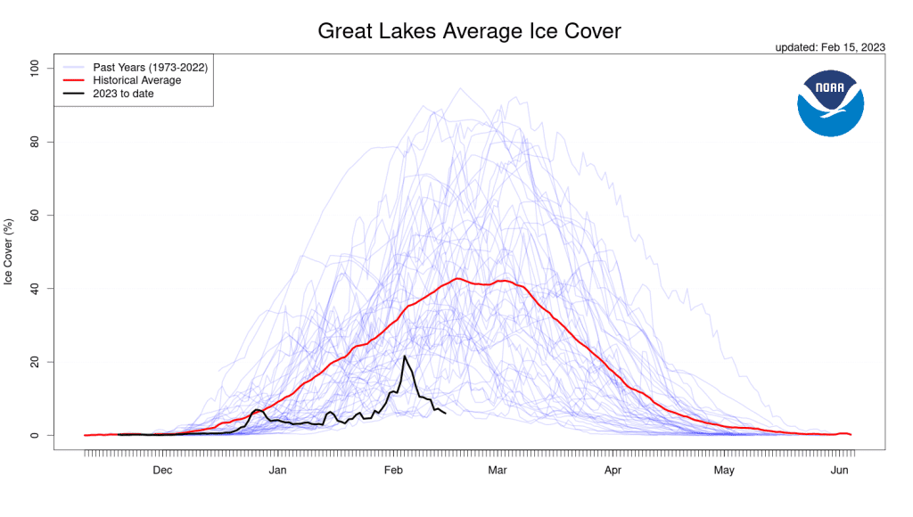
Editor’s note: The 2023 posting of this story has been corrected. After further analysis NOAA GLERL scientists report that the trend for Great Lakes ice is estimated to be decreasing by approximately 5 percent per decade for a 25 percent total decrease between 1973 and 2023. An earlier version of the post stated that it was about 70 percent, but that is not accurate.
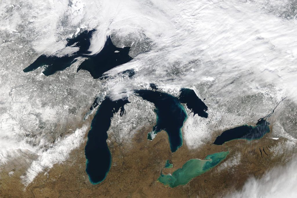
Ice coverage has reached a record low in the Great Lakes for this time of year.
As of February 13, 2023, only 7 percent of these five freshwater lakes was covered in ice, which is significantly below the 35-40 percent ice cover that is expected for this time of year, according to NOAA’s Great Lakes Environmental Research Laboratory (GLERL).
Ice extent across the basin briefly jumped up to 21 percent in early February in response to a cold snap, but has been declining since. Maximum ice cover typically occurs between mid-February and early March.
NOAA has been keeping records on the Great Lakes ice extent since 1973.
Air temperatures are the main factor affecting ice cover on the Great Lakes, and a warmer than average January contributed to the lack of ice. According to the U.S. National Ice Center, each of the five lakes experienced warmer than average air temperatures in January. In addition, it was an especially warm January across the contiguous U.S.: The average temperature was 35.2 degrees F (5.1 degrees above average) according to NOAA, and January 2023 Earth’s seventh-warmest January on record.
Although there is year-to-year variability in the ice cover of the lakes, NOAA research has found that, on average, Great Lakes ice cover is declining. The Annual Maximum Ice Cover is decreasing by a rate of 5% per decade based on data from 1980-2020.
Ice cover protects the shoreline of lakes – without it, high waves can scour the coastline and cause severe flooding.
Low ice coverage on the lakes can be a set up for large severe “lake effect” snow storms, says Ayumi Fujisaki-Manome, a researcher at NOAA’s Cooperative Institute for Great Lakes Research at the University of Michigan. “The moisture and heat from the lake surface water are absorbed into the atmosphere by storm systems, and then fall back to the ground as snow in the winter. When ice is not present, we can end up with big snow storms like those that hit Buffalo, New York in December.
Although human-caused warming plays a role in this decline, other key factors contributing to reduced ice loss are long-term patterns of climate variability over the Pacific and Atlantic oceans. Four patterns of climate variability are contributing to ice cover changes: the North Atlantic Oscillation, the Atlantic Multidecadal Oscillation, the Pacific Decadal Oscillation, and the El Niño-Southern Oscillation.
“Each year, we have to look at these four patterns to model ice cover,” said Wang. “Right now, the Pacific Decadal Oscillation together with the North Atlantic Oscillation are causing warming in the Great Lakes.”
GLERL will continue to monitor the ice levels, and will announce end-of-season ice extent later this year.
For more information, please contact Alison Gillespie, NOAA Communications, at alison.gillespie@noaa.gov