Major hurricanes, intense wildfires, increasing concentrations of greenhouse gasses, deep sea discoveries, and more made 2022 an eventful year for NOAA Research. As we enter the final days of the year, we’re taking a look back at some of our biggest research stories from the last 12 months.
Preparing the nation for the impacts of climate change
People across the country are feeling the impacts of climate change through severe droughts, wildfires, catastrophic flooding, major hurricanes, heat waves and more. Working closely with our partners, NOAA is building a climate-ready nation through science, service, stewardship, and a sharp focus on equity.
The nation has been facing widespread droughts which affect every sector of the national economy, costing U.S. tax-payers billions of dollars in damages. This year, NOAA Research continued its work with a multi-agency partnership that coordinates drought monitoring, forecasting, planning, and information at national, state, and local levels across the country. In October 2022, a new national drought Action Plan was released, which reflects the need to better understand drought impacts to the economy, ecosystems, public health, and the interactions of drought and wildland fire in specific locations and how these may be connected across regions.
In addition to drought, extreme heat, whether in the form of rising long-term average temperatures or punctuated by heat waves, is also a serious health threat. In the US, it is already deadlier than all other natural disasters, and it will clearly be exacerbated by a changing climate. This year, NOAA Research continued its work with other federal agencies to launch Heat.gov, a new website that provides the public and decision makers with clear, timely and science-based information to understand and reduce the health risks of extreme heat. Heat.gov serves as the premier source of heat and health information for the nation and was showcased in November at COP27 in Sharm El Sheikh, Egypt.
While Heat.gov is useful for understanding land-based heat events, NOAA researchers have developed global forecasts that can provide up to a year’s advance notice of marine heatwaves and can be used to help fishing fleets, ocean managers, and coastal communities anticipate the effects of marine heatwaves. Marine heat waves can also impact the development and intensification of hurricanes, which put U.S. coastal communities at greater risk of flooding. In response, NOAA released the Coastal Inundation Capability Framework report that describes how federal agencies can better provide data, products, and services that inform community adaptation decisions and communicate the risk of coastal flooding and inundation for the U.S. and its territories.
Greenhouse gas emissions on the rise, ozone hole on the mend
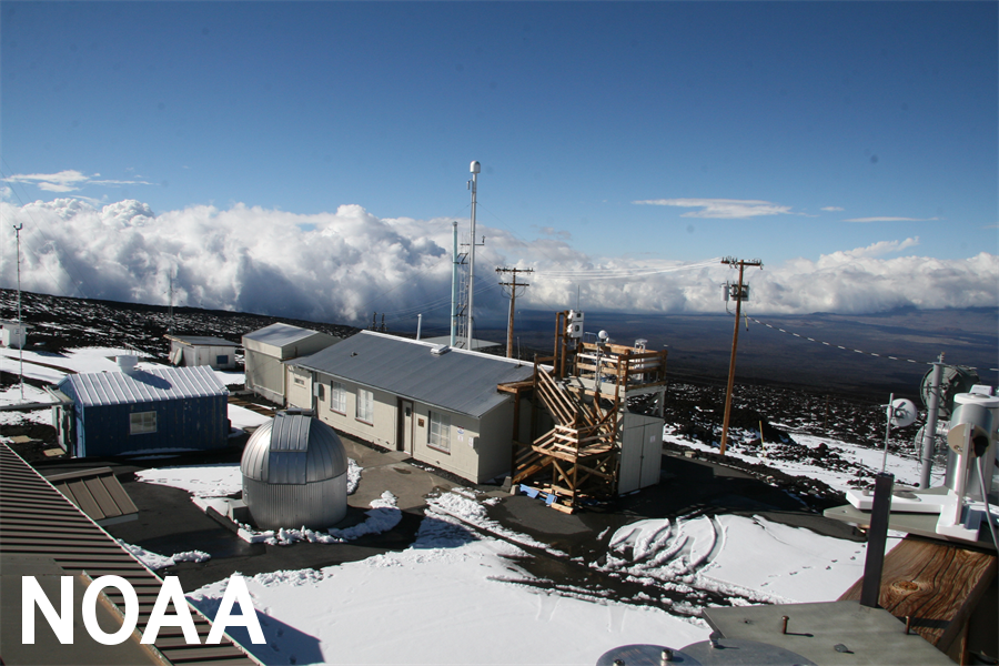
Greenhouse gas emissions reached an unprecedented milestone in 2022, with carbon dioxide now more than 50% higher than pre-industrial levels. Carbon dioxide measured at NOAA’s Mauna Loa Atmospheric Baseline Observatory peaked at 421 parts per million in May, pushing the atmosphere further into territory unseen in millions of years. While the globe goes through natural cycles of warming and cooling, the NOAA Annual Greenhouse Gas Index (AGGI) can track the rate at which humans are driving global warming. Earlier this year it was confirmed that in 2021 human-emitted greenhouse gasses trapped nearly 50 percent more heat in the atmosphere than in 1990. If the current level of emissions persists, there is a 50 percent chance that global warming of 1.5 degrees Celsius (2.7 degrees Fahrenheit) will be exceeded in nine years, the opposite trend needed to reverse climate change.
It is not all bad news when it comes to emissions. An annual analysis showed the overall concentration of ozone-depleting substances in the mid-latitude stratosphere had fallen just over 50 percent back to levels observed in 1980, before ozone depletion was significant. The recovery of the ozone layer is important as it absorbs the sun’s harmful ultraviolet rays and protects all biological systems on Earth. Ozone depleting substances include two popular classes of chemicals known as chlorofluorocarbons (CFCs) and hydrofluorocarbons (HFCs). CFCs were internationally banned in 2010 and replaced with HFCs as a safer, less toxic option. Unfortunately, that was not the case as HFCs were later found to be super-potent greenhouse gasses which also depleted the ozone layer. This year, NOAA science expertise and data supported the U.S. government’s decision to approve the Kigali Amendment of the Montreal Protocol which aims to reduce HFC emissions by 2036.
Learning more about hurricane intensification through new technology and research
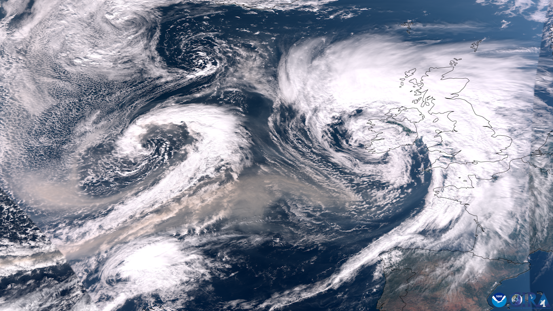
The 2022 Atlantic hurricane season had a total of 14 named storms with eight becoming hurricanes. Of the eight hurricanes, two intensified into major hurricanes. NOAA Research scientists worked long hours deploying new technology, developing modeling systems, flying into the eye of hurricanes, and working side by side with research partners and forecasters to improve our understanding of how these storm systems work.
At the beginning of this year’s hurricane season, NOAA partnered with Saildrone Inc. to launch seven hurricane-tracking Saildrones. Saildrones are one of many uncrewed systems used by NOAA to collect pertinent data from areas that are too dangerous for scientists to travel to. In addition to Saildrones, NOAA also deployed underwater hurricane gliders, drifters, ARGO Floats, eXpendable BathyThermographs, and for the first time, the Altius-600 drone. Together, these technologies provided a snapshot of the marine environment during tropical cyclone conditions. In addition to the collection of uncrewed systems, NOAA Research hurricane hunters took to the sky, completing a total of 72 research and operational missions on Hurricane Hunter aircraft. In late August, hurricane researchers spent 12 consecutive days conducting 20 research missions into the storm system which was later named Hurricane Earl, marking the longest series of missions into a single tropical system ever conducted by NOAA.
These improvements in data collection and monitoring are increasingly important as climate change influences the frequency and intensity of tropical cyclones and the threats they pose to our coastal communities. The decreasing concentrations of human-caused air pollution in the Northern Hemisphere, estimated to be a 50 percent drop in concentration from 1980 to 2020, has led to surface warming over the tropical Atlantic Ocean, which contributes to more frequent tropical cyclones. Without significant amounts of particulate pollution to reflect sunlight, the ocean has absorbed more heat and has been warming faster. A warming Atlantic Ocean has been a key ingredient to a 33% increase in the number of tropical cyclones during this 40-year period. In addition to increasing ocean temperatures leading to more hurricanes, NOAA scientists have found that Atlantic coast hurricanes are also intensifying faster than 40 years ago, and will likely continue in the future.
How wildfire research improves fire and smoke predictions
Americans experienced devastating, and in some cases record setting, wildfires over the last few years. This year, NOAA Research studied what causes these fires to become so extreme and what impacts they have on local and global systems. The Marshall Fire, which occurred on December 30, 2021, burned more than 6,000 acres, and destroyed more than 1,000 homes. The fire was spread by hurricane force winds, but winds alone didn’t account for the destruction. Researchers found that wet, then dry extremes contributed to the devastating fire. Spring rains drove a spike in vegetation levels, but as the year progressed the area went into a drought and had abnormally late winter snow falls, leading the dry vegetation to become the perfect tinder to support a blaze like the Marshall Fire.
Large wildfires, such as the Marshall Fire, and severe heat events are worsening air pollution across the western United States. On one day in 2020, more than 68 percent of the U.S. West—representing about 43 million people—were affected by harmful levels of air pollution, the highest number in 20 years. This year, NOAA researchers found that widespread air pollution events are not only increasing in frequency, but also persisting longer and affecting a larger geographic area. These events have become so bad that they have reversed many gains of the Clean Air Act—and the conditions that create these episodes are expected to increase, along with their threats to human health. Along with causing air pollution that is harmful to humans, NOAA researchers found that these wildfires produce smoke that influences ozone pollution on a global scale. Something that surprised researchers was the discovery that fire emissions are actually contributing equal or greater amounts of ozone to the remote atmosphere than urban pollution. Given that ozone is a regulated air pollutant, and also contributes to climate change, it is important to understand the sources of ozone to properly represent it in global models.
Being able to accurately predict where wildfire smoke and associated pollutants are traveling is important for improving forecasts and health advisories. NOAA Research used the 2018 Camp Fire to test the accuracy of the HRRR Smoke model and found that the model accurately predicted the general movement and concentration of fire’s smoke during the initial week of the lengthy blaze. The HRRR Smoke model calculates a fire’s size and couples that information with weather simulations from NOAA’s High-Resolution Rapid Refresh (HRRR) short–term weather model to produce forecasts of near-surface smoke and smoke aloft. While this was a success for the model, researchers used the data collected to determine improvements that can be made to the model in the future.
Exploring the deep leads to new discoveries, and new questions
We know less about the ocean floor than we do about the surface of the Moon and Mars. As of this summer, 23.4 percent of the ocean has been mapped, reflecting an increase of almost 3.9 million square miles (10.1 million square kilometers) of new bathymetric data from last year. This summer NOAA Administrator Rick Spinrad signed a memorandum of understanding at the United Nations Oceans Conference that outlines U.S. participation in Seabed 2030, an international mapping initiative to produce a definitive map of our oceans by 2030. This memorandum describes best practices and protocols for ocean mapping data collection and is expected to build positive collaboration between all involved countries and partners.
This year, NOAA Ocean Exploration scientists explored areas nearly four miles below the ocean’s surface during their Voyage to the Ridge 2022 expedition. On the fourth dive of the second expedition, researchers navigated an underwater volcano when they started to observe sets of mysterious sublinear holes along the seafloor. Researchers attempted but were unable to see into the holes and poke them with the tools on the remotely operated vehicle. It is still unclear what sort of organism made these holes; however, they were seen multiple times throughout the expedition in various locations. Another mystery was encountered on the eighth dive of the third expedition, while exploring southwest of St. Croix. Scientists repeatedly encountered an unknown blue organism that experts think may be a soft coral, sponge, or tunicate, however no one has been able to confidently identify it.
In addition to exploring never before seen parts of our oceans, researchers discovered multiple culturally significant underwater sites. One of the year’s biggest discoveries for NOAA Ocean Exploration and partners was the wreck of a 207 year old whaling ship, called Industry, found at the bottom of the Gulf of Mexico. The remains of the 64-foot long wooden ship opened a window into a little known chapter of American history when descendants of African enslaved people and Native Americans served as essential crew in one of the nation’s oldest industries. Another significant site was found in Southeast Alaska where scientists discovered what might be the oldest stone fish weir ever found in the world. Previous studies have confirmed that Indigenous people lived in Southeast Alaska at least 10,000 years ago, however the weir is believed to be 11,000 years old, pushing back the date of Indegious occupation by 1,000 years.
Want to learn more about what happens at NOAA Research? Stay updated on exciting research findings throughout 2023 by following us on Twitter, Facebook, and Instagram!
For more information, please contact Emily Ashe, NOAA Research Communications, at emily.ashe@noaa.gov.