Salt has played an outsized role in human history. This element found in the ocean is now at the heart of new NOAA research that will potentially lead to improved forecasts of the most dangerous hurricanes. Salt has played an outsized role in human history. This element found in the ocean is now at the heart of new NOAA research that will potentially lead to improved forecasts of the most dangerous hurricanes. While NOAA has made steady progress in forecasting the track of a hurricane, progress has been slow in improving prediction of what’s called rapid intensification of hurricanes. This is when the maximum wind speeds that drive a hurricane rapidly increase by 35 miles per hour or more in 24 hours or less. A prime example was Hurricane Michael in 2018, a Category 5 hurricane that came ashore on the Florida Panhandle with 160 mph ferocious winds, leading to 16 deaths and $25 billion in damages. So what’s the connection to salt? It is well known that one of the key ingredients for hurricanes to rapidly intensify is warm sea surface waters. And these waters are sometimes prevented from cooling due to a lack of saltiness.
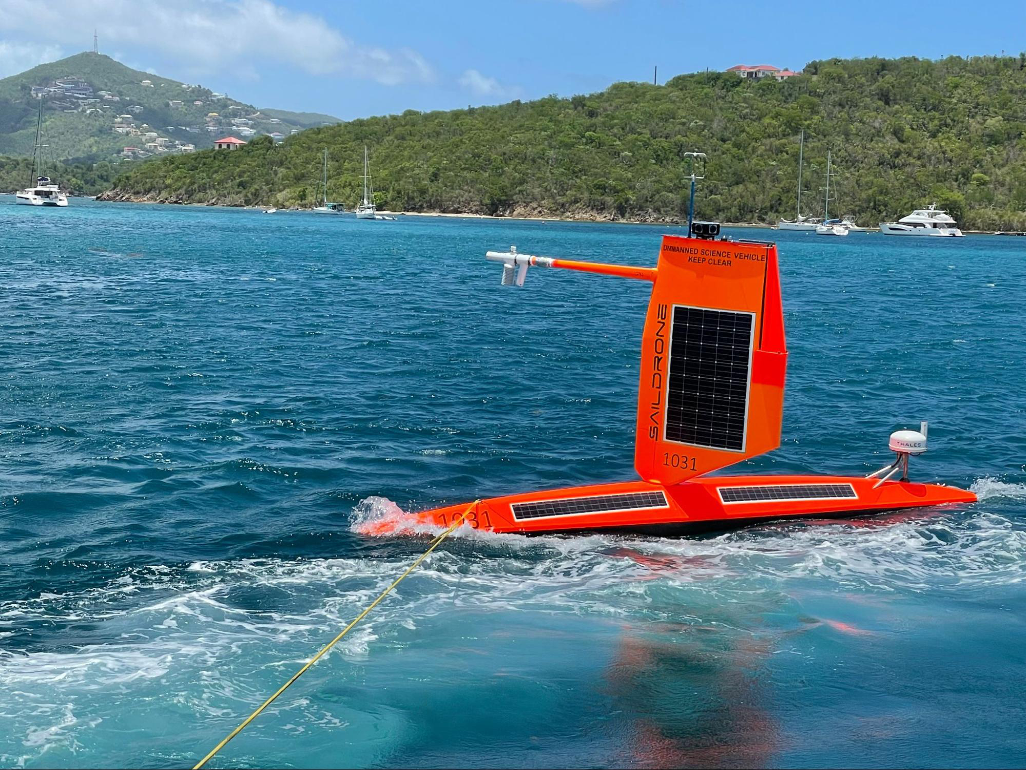
What’s happening is that freshwater from major rivers that flow into the ocean where hurricanes form and grow can create a layer on the surface of much warmer, fresher water. This layer can inhibit the saltier cooler ocean water from the deep from rising and mixing and cooling the ocean. Without this cooling, hurricanes slurp up more heat energy from the ocean and are more likely to strengthen rapidly, contributing to increasing winds. This research comes at a time when scientists are predicting that climate change will make rapid intensification of hurricanes more frequent, especially in the Gulf of Mexico and along the east coast of Florida. Research shows that hurricanes that see winds rapidly intensify by 70 mph in 24 hours happen once every 100 years but are projected to occur once every 5-10 years by 2100 if warming continues, said Greg Foltz, oceanographer and hurricane researcher at NOAA’s Atlantic Oceanographic and Meteorological Laboratory in Miami. “The bottom line is that when salinity is lower in the ocean, rapid intensification is more likely,” Foltz added. Scientists have observed this occurring in the western Caribbean and Atlantic near where large amounts of freshwater flow from the major rivers of the Amazon, Orinoco and Mississippi. Saildrone provides new data from within hurricanes This past hurricane season, NOAA teamed up with Saildrone to dramatically expand ocean observations of ocean salinity and temperature, with the goal of improving hurricane forecast models of the future. Saildrone’s specially-designed autonomous surface vehicles were equipped with sensors to track the exchange of energy between the ocean and atmosphere at the ocean surface. Five of the Saildrones were carefully directed into the paths of major hurricanes over three months. They successfully withstood hurricane winds and waves, transmitting near-real-time data to shore. One Saildrone, SD 1045, made a historic mission into the eyewall of Category 4 Hurricane Sam in the Atlantic Ocean. The Saildrone spent 24 hours inside hurricane winds of more than 90 mph and was buffeted by waves higher than 50 feet, providing data and a video such as the world has never seen of what it’s like to be rocked by a major hurricane. The marvel was it survived and continued to transmit data for the rest of the hurricane season as planned. This season’s NOAA hurricane research with Saildrone also showed potential for using multiple, coordinated observing systems to obtain more detailed data on hurricanes as they form, transform and intensify. “When we combine the Saildrone with additional assets like underwater gliders, we get a more complete picture of what’s going on in the ocean,” said Chris Meinig, director of engineering at NOAA’s Pacific Marine Environmental Laboratory in Seattle. NOAA and Saildrone coordinated with a fleet of diving ocean gliders as well as NOAA Hurricane Hunter aircraft to collect data from nearly the same positions, at different levels of ocean and atmosphere. The long-term goal is to have coordinated systems that can collect data within the ocean, at the surface, in the air near the ocean surface using drones, higher in the atmosphere with manned aircraft and from space using satellites to gain a more complete understanding of the development of hurricanes. This detailed data will enable NOAA to improve forecast models and hurricane forecasts that provide greater warning times to help save lives, reduce property damage and strengthen our economy. To learn more about this 2021 NOAA Saildrone hurricane research mission and view a new video of Saildrone footage from inside Hurricane Sam, please see Saildrone’s blog post on the 2021 Hurricane Season and a new video from inside Hurricane Sam. For more information, please contact Monica Allen, director of public affairs at NOAA Research, at monica.allen@noaa.gov or 202-379-6693.